The making of a map
September 23, 2026
Inspired by the upcoming centennial of one of the library's most beloved maps, curator Anna Rohl set out to find out more about how and why it was made, the women who made it, and how it fits into a larger story about women's contributions to map-making over many centuries.
The map, Down in Ann Arbor Town Where No One Asks the Who or Why: University Of Michigan, the College Whose Colors We Wear, was created by Gertrude A. Strickler and Jessie Horton Koessler (Class of 1901) to raise funds to build the Michigan League, a recreational and social place for women, who were barred from using the Michigan Union without a male chaperone until 1968.
The map played a key role in raising the $1 million (the equivalent of around $20 million in 2026) needed to secure the plot on Ingalls mall where the League stands today, and the map's proceeds eventually funded a library of popular reading materials inside the League, named after Koessler.
Its bright colors, whimsical style, and depictions of students at leisure in some still-familiar campus locations all contribute to its enduring popularity. And it's the highlight of the exhibit Down in Ann Arbor Town: Pictorial Maps, Campus Traditions, and the Women Who Made Them.
The investigators
Rohl arrived at the University of Michigan Library after earning master's degrees in both history and library science at the University of Wisconsin-Milwaukee and working at the Milwaukee Public Library.
Her area of responsibility is expansive — the library's collection of maps in among the largest in North American, and includes many rare items that require attentive stewardship — but she still finds the time and resources to pursue an enduring interest in how maps and other visual records shape their viewers' understanding of their place in an increasingly connected and complex world.
Maps and atlases are often misunderstood as objective renderings of reality, Rohl explains. But maps are made by people (modern technology notwithstanding), and people have points of view that they invariably infuse into their cartography, whether intentionally or otherwise.
"Curating a collection of cartographic materials requires both a critical perspective about those viewpoints, and also an intentional search for items that represent more marginal ways of seeing the world," Rohl says.
"Down in Ann Arbor Town" presented a particularly intriguinging opportunity — the 100th anniversary of a map that leads with a point of view by and for women, some unknowns about its makers that Rohl thought she might be able to uncover, and a chance to perhaps discover and acquire other works like it also made by women.
Pictorial maps like "Down in Ann Arbor Town," which offer artistic rather than technical depictions of places and regions, helped solidify aspects of American pop culture in the 20th century.
They also, Rohl found, created opportunities for women artists and cartographers to not just create or contribute to maps — something women had been doing for centuries — but to get explicit credit for their work — something that was much harder to come by, even well into the 20th century.
Her research led to a few different places, including the Wellesley College Archives; the Leventhal Map and Education Center at the Boston Public Library; the Vassar College Archives and Special Collections Library; and (digitally) the David Rumsey Historical Map Collection, which includes thousands of pictorial maps that are viewable online.
But one key venue was close to home: the Bentley Historical Library on North Campus, keeper of the archives of the University of Michigan — archives that, unsurprisingly, include a copy of "Down in Ann Arbor Town," along with at least some of the story of how it came to be, as well as some of the keys to interpreting the map's depiction of the student experience at the University of Michigan in the midst of the Roaring Twenties.
Enter Ava Pustulka, class of 2028 and student worker in the Clark Library, home of the map collection. After she spent more than a year providing vital assistance to visitors to the Clark — everything from wayfinding assistance to helping people access maps and other resources — Rohl asked her to serve as research assistant. Pustulka was immediately enthusiastic.
"I hadn't really done any archival research before," she says, though working in the map collection provided glimpses into the scholarly value of rare and unique library materials. She also has a longstanding interest in campus history, as a native Michigander born at the U-M hospital, and a special affection for The League, which is a favorite study spot. So heading to the Bentley for an investigation into the "Down in Ann Arbor Town's" origins, with its close ties to the origins of The League, was an enticing prospect.
The findings
The exhibit Rohl and Pustulka put together centers on the story of how the map came to be and the women who made it. Its named creators are Jessie Horton Koessler, U-M alum and medical researcher, and Chicago-based artist Gertrude A. Strickler. Among the unknowns they pursued is how the artistic contributions to the map were divided between these women.
Their findings prompted Rohl to update the catalog record to reflect the fact that Koessler, long understood as the driving force behind the map's production, very likely also participated in its design, having studied art after an early retirement from medical research. Her artistic career was short-lived; she died less than a year after the map was published. But her dedication to the cause of building the League is still memorialized in the room named for her.
Koessler's story is particularly compelling. She attended the university at the turn of the 20th century, when a college education for women was largely reserved for serious scholars preparing for careers (when offered at all). Two decades later, the map she created illustrates a transformation: women were attending college as much for social as educational purposes, and the map emphasizes that social side — one that must have been quite different than her own campus experience in the 1890s, and that she nevertheless celebrated and sought to build upon for future generations of women.
The exhibit features photographs of some of the many campus traditions cited on the map and that have given way in the last hundred years, including the Sophomore Circus, the Architect's Ball, and the Freshmen Pageant and Picnic.
It also zooms out for a look at 20th-century pictorial mapmaking, particularly highlighting women's contributions to similar campus and other pictorial maps, and examining the broad question of who gets credit for the making of map when it's often the work of teams.
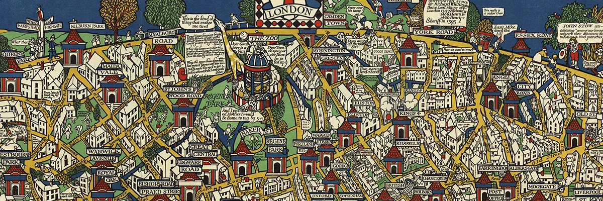
Among the maps in the exhibit is MacDonald Gill’s "Wonderground Map of London Town," which was made in 1914 to encourage Londoners to use the city’s subway system, and which became wildly popular. Today it's known as the map that saved the London Underground by expanding its use beyond the morning and evening commute, and its design and style influenced many a 20th-century pictorial map, including Down in Ann Arbor Town.
There's more
If you can't make it to the Clark Library, you can visit an online version.
Programming related to the exhibit includes a talk by Rohl and Pustulka, where they share research done for the exhibit; and an October 28 visit by artist Elaine S. Wilson, whose project Charting the Wolverine combines art and mapmaking in an effort to "capture...with a clear eye" the Amtrak line that runs between Pontiac, MI and Chicago, IL.
by Lynne Raughley
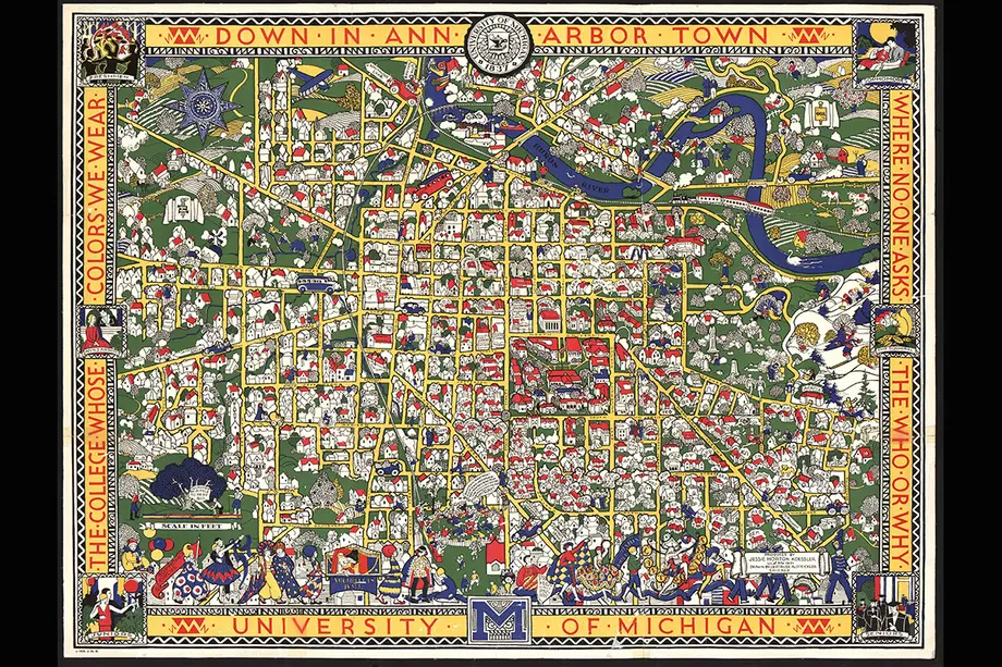
Down in Ann Arbor Town..., by Jessie Horton Koessler and Gertrude A. Strickler, 1926.