The Move to Ann Arbor & the 1840 Plan

cropsey_painting.jpg

Jasper Francis Cropsey's painting of the University of Michigan campus, 1855. This painting depicts Michigan's classical campus just before the outbreak of the Civil War.

Moving to Ann Arbor

In March of 1837, the university in Detroit was offered two parcels of land in nearby Ann Arbor by the Ann Arbor Land Company. The regents selected Site B (see below), which is the core of today’s Central Campus (Duderstadt, p. 4). The chosen plot was largely made up of level farmland and peach orchards. The majority of Site A was later acquired and incorporated into the campus in the 1970’s.

3.1.jpg

In 1837, the village of Ann Arbor offered the regents of the Detroit college two 40 acre plots of land for the establishment of the state university, one of which had previously been offered as land for the new state capitol. The regents initially chose Site B, but in the 1970s much of Site A was also incorporated, as part of the purchase of the former St. Joseph Mercy Hospital complex.

A plan for campus development was needed, and in 1838 the regents hired architect Alexander Jackson Davis. Soon thereafter they adopted his plan for the new campus, which featured Gothic style buildings set in a park-like setting (see Davis’s plans below). One of Davis's ideas included a signature building facing State Street with expansion around the north east and south peripheries. Sadly, the plan was later vetoed due to financial concerns.

DT369502.jpg

Davis's master plan featured a large Gothic-style building set in a park-like setting.

AJD_campusplan.jpg

Jackson employed a grid to layout other potential buildings, and set aside a large area for a botanical garden.

DT258988.jpg

Alexander Jackson Davis's design that was adopted by Governor Mason for the University of Michigan, 1838.

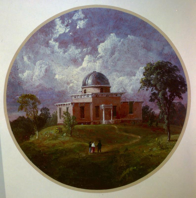
With the University growing in its new Ann Arbor location, a new plan for campus development was commissioned in 1840. Unfortunately, no copies of the original plan, which was likely created by Harpin Lum, exist today, but the design is preserved on the 1854 Pettibone map (see below). The main feature of the 1840 plan was a row of buildings facing State Street with professors' houses along North and South University Avenues, an idea which guided the development of campus for the next 40 years. The plan also included botanical gardens on the east side of campus. One of the most significant changes to the university during this period was the incorporation of applied research and the sciences, which influenced the decision to build specific buildings, such as the Detroit Observatory (1854) and the Medical Building (1850). Over the next 30 years, several buildings were added, but were not placed according to any specific plan.

1854 -- City of Ann Arbor, Washtenaw Coty. Michigan.jpg

Pettibone based his depiction of campus on the “1840 plan,” of which no copies exist, and so this is the closest representation of that plan that we have. It shows a collegiate row of buildings along State St. that would be the model for campus growth for the next fifty years. The Greek Revival style building between Mason Hall and the South College building is “West Front Michigan University” and did not actually exist. The other buildings in existence in 1854 were the Medical Building (1850) on the east edge, and the four professor’s houses and their wood sheds. Of special note is the Detroit Observatory at the eastern edge of the map. It opened in 1854, and was the creation of President Henry Tappan, whose dream was to transform the fledgling school into a great research university.

1854_annarbor.jpg

The 1840 plan for the University of Michigan campus is visible on this enlargement of Pettibone's 1854 map. Though several maps from this time period bear the name " Michigan State University," the University of Michigan never went by this name. 

1844_enlargement.jpg

This portion of a map of Washtenaw County shows the Ann Arbor area with great accuracy.  Of note are the early [Michigan] Central Railroad, saw and flour mills along rivers and creeks, descriptions of the land, and early roads. Interestingly, the university is inaccurately portrayed. It appears to be showing buildings proposed by A.J. Davis in his 1838 plan. Only the four professors’ houses and the North Wing had been built by 1844.

The Founding (1817-1837)

First buildings